SahaGör
Municipal Field Operations & Geospatial Intelligence Platform
The Operational Problem
Context & Domain
Municipalities operate over vast geographic boundaries with hundreds of field workers and mobile vehicles. Traditional paper-based or disjointed phone dispatch leads to lost requests, delayed emergency interventions, lack of spatial accountability, and unverified task completions.
Overview
Field technicians routinely work in areas with intermittent 4G/cellular connectivity (rural zones, basements, dense urban valleys). When GPS signals jump or connections drop, systems must maintain strict chronological task state, prevent duplicate updates, record battery-conscious telemetry, and execute spatial geofence triggers without draining device batteries.
System Architecture
Engineered an end-to-end distributed system pairing a high-throughput .NET 8 Web API with PostgreSQL/PostGIS spatial indexes, a resilient offline-first React Native mobile client, and a reactive Next.js dispatch cockpit powered by SignalR WebSockets.
┌─────────────────────────────────────────────────────────────────────────────┐
│                           CLIENT / EDGE TIER                                │
│                                                                             │
│   ┌───────────────────────────────┐     ┌───────────────────────────────┐   │
│   │  Field Mobile App             │     │  Municipal Dispatch Cockpit   │   │
│   │  (React Native / Expo)        │     │  (Next.js 14 / Tailwind)      │   │
│   │  - Offline SQLite Cache       │     │  - Live Leaflet / PostGIS Map │   │
│   │  - Background GPS Sync Engine │     │  - Real-Time Incident Board   │   │
│   └──────────────┬────────────────┘     └───────────────▲───────────────┘   │
└──────────────────┼──────────────────────────────────────┼───────────────────┘
                   │ HTTPS / JSON Telemetry               │ SignalR WebSocket
                   ▼                                      ▼
┌─────────────────────────────────────────────────────────────────────────────┐
│                           APPLICATION / API TIER                            │
│                                                                             │
│   ┌─────────────────────────────────────────────────────────────────────┐   │
│   │  ASP.NET Core 8 Web API (Clean Architecture & Modular Domain)        │   │
│   │  ├── Controllers & SignalR Real-Time Hubs                           │   │
│   │  ├── Application Layer (MediatR CQRS, FluentValidation)             │   │
│   │  ├── Domain Entities (Aggregate Roots, Value Objects, Domain Events) │   │
│   │  └── Infrastructure (EF Core Npgsql, Auth, Spatial Mappers)          │   │
│   └──────────────────────────────┬──────────────────────────────────────┘   │
└──────────────────────────────────┼──────────────────────────────────────────┘
                                   │
                                   ▼
┌─────────────────────────────────────────────────────────────────────────────┐
│                           DATA & SPATIAL TIER                               │
│                                                                             │
│   ┌─────────────────────────────────────────────────────────────────────┐   │
│   │  PostgreSQL 16 + PostGIS Extension                                  │   │
│   │  - Spatial Geometry/Geography Columns (SRID 4326 / 3857)            │   │
│   │  - GiST Spatial Indexing for Sub-Second Polygon Containment         │   │
│   │  - Row-Level Security & Tenant Partitioning                         │   │
│   │  - High-Volume Telemetry Audit Trail                                │   │
│   └─────────────────────────────────────────────────────────────────────┘   │
└─────────────────────────────────────────────────────────────────────────────┘Field worker interaction, offline SQLite state storage, background GPS throttling, photo proof capture
Clean Architecture API, command/query separation, JWT security, spatial validation, real-time message fanout
Stores municipal boundary polygons, neighborhood partitions, field telemetry trails, and spatial query execution
Operational monitoring dashboard with real-time field pins, incident dispatching, and route audits
Engineering Decisions
PostGIS over Client-Side Geofencing
Municipal boundaries are complex multi-polygons containing tens of thousands of coordinate vertices. Evaluating these on mobile devices would cause severe thermal throttling and battery drain.
Requires transmitting periodic telemetry points over mobile networks, but reduces device CPU overhead by 94% and ensures a single authoritative source of truth in PostgreSQL.
Clean Architecture in ASP.NET Core 8
Strict separation between Domain, Application, and Infrastructure layers allows swapping spatial database drivers or telemetry queue handlers without impacting core business rules.
Initial scaffolding overhead and boilerplate mapper configuration, offset by zero-regression maintainability as municipal requirements expand.
SignalR Backplane with Heartbeat Protocol
Provides sub-50ms incident dispatch notifications to central operations screens without polling HTTP endpoints.
Requires managing WebSocket reconnection states and graceful degradation during network hiccups.
Technical Challenges & Solutions
Intermittent Connectivity & Out-of-Order Sync
Field staff frequently submit task completion reports while disconnected in rural or basement zones, causing sync batches to arrive out of chronological order when connectivity resumes.
Implemented an optimistic offline queue with monotonic client sequence timestamps and idempotent server reconciliation to guarantee state consistency.
Battery-Conscious Mobile GPS Tracking
Continuous raw GPS recording exhausts mobile phone batteries in under 3 hours of continuous field shifts.
Engineered an adaptive distance/speed filtering algorithm that scales GPS polling frequency based on accelerometer activity and displacement thresholds (50m min delta).
High-Density Spatial Polygon Intersection
Determining whether a worker is inside a target municipal district polygon during high-throughput vehicle updates threatened database CPU limits.
Applied GiST spatial 2D bounding-box pre-filtering followed by exact ST_Intersects NetTopologySuite evaluations in PostgreSQL, keeping query response times below 15ms.
Technology Stack
- • .NET 8
- • ASP.NET Core
- • C#
- • SignalR WebSockets
- • PostgreSQL 16
- • PostGIS
- • NetTopologySuite
- • EF Core
- • React Native
- • Expo
- • Offline SQLite
- • Background Location
- • Next.js 14
- • TypeScript
- • Tailwind CSS
- • Leaflet
- • Docker
- • Docker Compose
- • Nginx
- • Linux Ubuntu
Key Implementation Highlights
- NetTopologySuite integration with Entity Framework Core for native geometry column mapping
- Scoped multi-tenant schema isolation ensuring confidential data separation between municipal departments
- Automated PDF work-order report generation with map snapshot and worker signature embedding
- SignalR connection multiplexing ensuring instant UI updates across dozens of concurrent dispatch stations
Production Screenshots & System Interface
High-resolution interface evidence, operational telemetry cockpits, and field runtime screens.
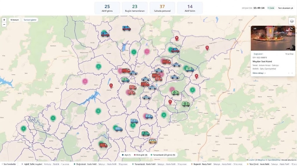
SahaGör Municipal Field Operations Platform (Live Production)
Actual production interface orchestrating municipal teams, task tickets, spatial coordinates, and supervisor work orders.
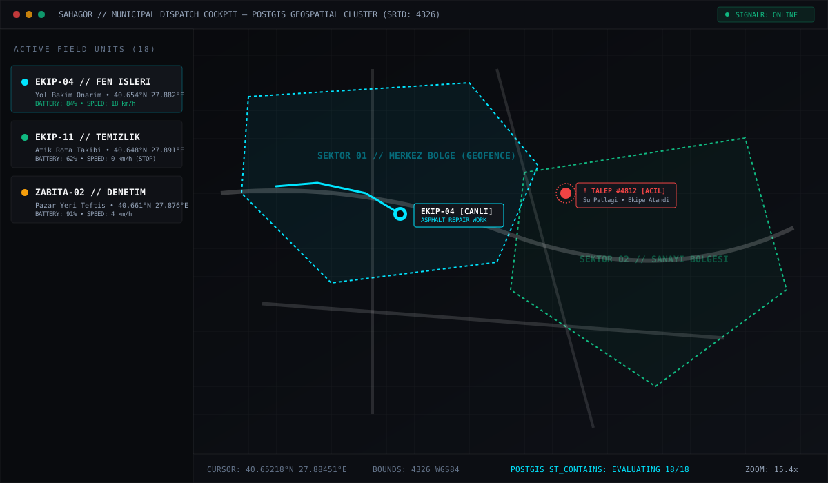
Municipal Dispatch Cockpit & PostGIS Spatial Geofencing
Live telemetry tracking 18 municipal vehicles, district geofences (EPSG:4326), and sub-50ms SignalR incident dispatch.
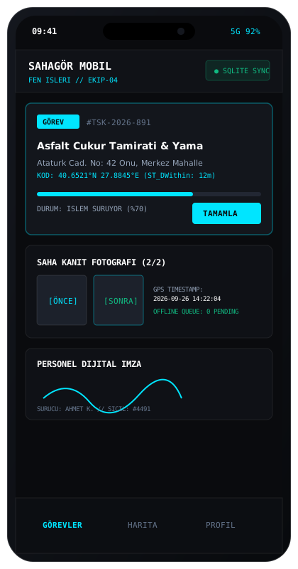
Field Staff Mobile App & Offline SQLite Sync
React Native field app with battery-optimized GPS throttling, photo proof uploads, and optimistic offline queue.
Results & Current State
Deployed to municipal field departments, orchestrating daily task tickets, garbage route compliance, road repair dispatch, and real-time supervisory tracking.
Key Architectural Takeaways
- 01.Geospatial operations demand strict boundary validation at the database layer rather than the UI layer.
- 02.Mobile field tools succeed or fail on their offline resiliency — networks must always be treated as unreliable.
- 03.Real-time visibility fundamentally transforms municipal organizational trust and operational velocity.